
High heat and humidity on tap for the weekend
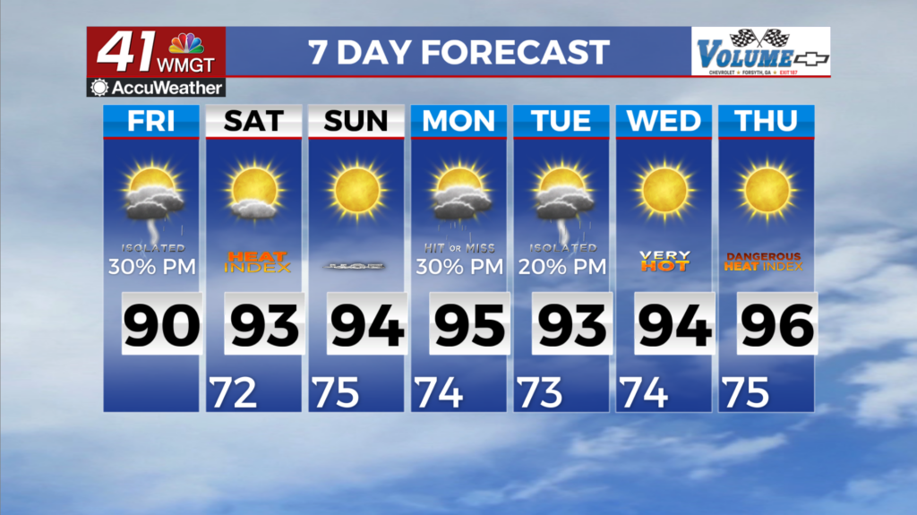
MACON, Georgia (41NBC/WMGT) – We can expect some residual moisture across the area Friday and another round of showers and isolated thunderstorms across east and Middle Georgia. 


Our next best chance for some storms will be Saturday as models are showing a wave moving southeast out of Tennessee across North and East Georgia Saturday through Saturday night. A weak wedge does build into Northeast Georgia ahead of the wave and the wave does weaken as it pushes across the Appalachian ridge into the region. Temperatures will continue to warm into the weekend with highs in the upper 80s to lower 90s expected through Saturday. A few lingering showers and thunderstorms will be possible late Saturday into early Sunday morning as a weak 


disturbance passes through the area. Chances for precipitation will be highest across northern locations. Moving into the later part of the weekend and into early next week, a ridge will center itself just west of the state over Mississippi and Louisiana. Given the strong ridge of high pressure, calm and dry conditions are expected through much of the period. With that being said, dangerously hot temperatures and heat index values are expected. Some low end chances of precipitation are possible underneath this ridge but the main hazard will be the hot and humid conditions leading to dangerous heat index values this weekend and into early next week. Temperatures are expected to be above average. Maximum heat index values will likely get into the upper 90s to just over 100 degrees across much of the state by late this weekend and continuing into early next week. Please exercise caution if you are outdoors and stay hydrated!