

The warm-up begins for Middle Georgia
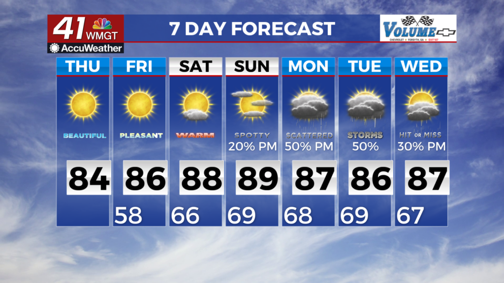
MACON, Georgia (41NBC/WMGT) – Today begins a gradual heating trend that will continue through the rest of the work week. Winds will slowly shift to the southeast over the next few days 


as high pressure assumes control, but should be on the lighter side at less than 5 mph. Overnight lows will be in the upper 50s and lower 60s. The extended forecast begins on Friday with an upper level ridge extending from the Deep South towards the eastern Great Lakes. Broad high pressure associated with this ridge will be centered over the Appalachians. A drier airmass remains in place under the high pressure system and that will inhibit rain chances throughout the day on Friday. Low temperatures on Friday will largely start the morning in the mid 50s to near 60. 


High temperatures will continue their gradual climb, rising into the mid to upper 80s across the majority of the area on Friday afternoon. A reprieve from the recent muggy conditions is also expected to continue on Friday, with minimum Relative Humidity Values expected to drop between 30 to 40 percent. The ridge continues eastward towards the Atlantic on Saturday, and will dampen as a shortwave trough quickly traverses the northern stream through the Midwest. As the ridge axis shifts east of Georgia and southwest flow sets up, Gulf moisture will begin to work its way back into the forecast area. Low temperatures on Saturday will reflect the increasing dewpoints, starting the morning in the low to mid 60s. High temperatures will mainly be in the mid 80s in North Georgia and upper 80s in Middle Georgia are expected Saturday afternoon and well into next week. An isolated shower or thunderstorm cannot be ruled out in West Georgia as early as Saturday afternoon, but the likelihood is less than 10 percent at this time. The ridge and surface high become centered offshore by Sunday, setting up a more Summertime Bermuda High pattern. Models continue to depict a pattern supporting diurnally driven thunderstorms on Sunday and into next week. Chances will be highest in the afternoon hours, generally ranging from 40 to 60 percent each day. In the absence of large scale forcing, widespread organized severe weather is not expected at this time. Isolated stronger storms could produce gusty winds, locally heavy rain, and frequent lightning.