

Another scorcher before pop up showers arrive
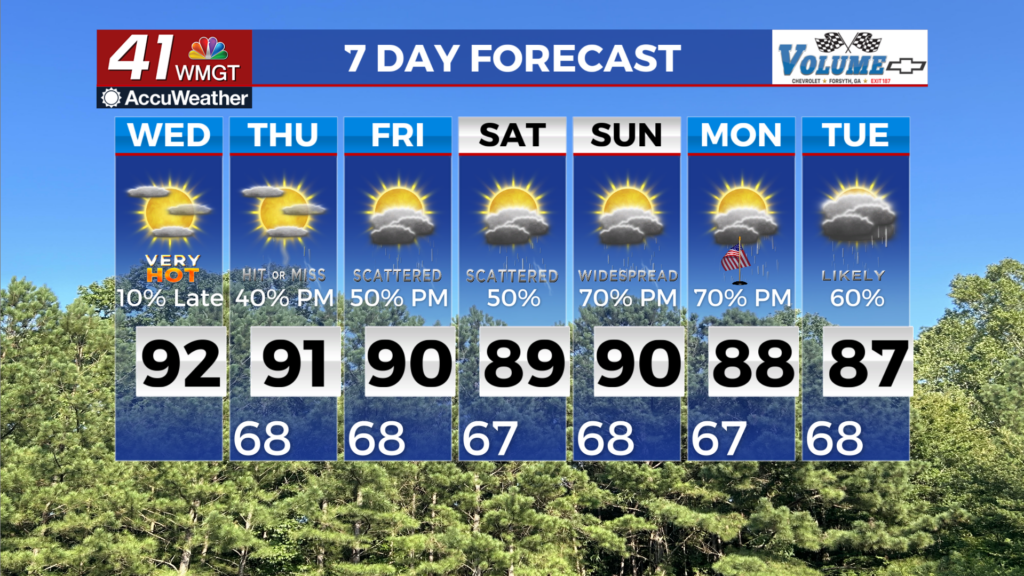
MACON, Georgia (41NBC/WMGT) – Winds turn out of the southwest for Wednesday, bringing moisture back into the region which will lead to a return of rain chances. Skies will start off 


mostly clear, with cumulus clouds building and becoming widespread during the afternoon as moisture values increase in west/northwest Georgia. This area will likely see isolated to scattered showers and storms developing during the late afternoon and evening as instability peaks. Elsewhere, instability and moisture will be too low to result in anything more than brief isolated showers. Any storms that develop across northwest Georgia will be the garden-variety type due to low shear and meager instability, with brief gusty winds and lightning being the primary threats. High temperatures will again climb to the upper 80s to low 90s across the area. Not much has changed in the extended forecast. A weakening cold front will enter the far northern tier by the time 


the long term period picks up Thursday. Scattered showers and isolated thunderstorms will linger across north and west Georgia from Wednesday night with precipitation spreading further south through the day Thursday. As ridging over the Atlantic Coast and West Atlantic continues to flatten, the front will make slow progress southward on Thursday, eventually stalling north of I-20 amid southwesterly flow aloft. Temperatures and dewpoints will start the morning on Thursday in the mid to upper 60s across the area. High temperatures will be slightly cooler across far north Georgia, in the low to mid 80s behind the front compared to upper 80s elsewhere across north Georgia and low 90s over central Georgia. Hot and humid conditions will support diurnally enhanced convection, with 60% chance for North Georgia, and 20 to 40 percent across Middle Georgia. The front will become less defined and begin to lift back northward Friday within the southwest mid-level flow along the western side of the Atlantic ridge. This southwesterly flow will intensify as a second ridge approaches from the Great Plains, giving the front an additional push away to the north. While this ridge sets up over the eastern U.S. during the weekend, the southwesterly flow continues to spread ample moisture into the region. Temperatures rise into the 80s and low 90s each day along with ample moisture will lead to scattered to numerous shower and thunderstorm activity each day through the beginning of next week. Coverage of these storms will be greatest during the afternoon and evening.