


A frigid start to Thursday for Middle Georgia
MACON, Georgia (41NBC/WMGT) – The main story for today will be very cold wind chills this morning and increased fire danger conditions by the afternoon. Temperatures will continue to 


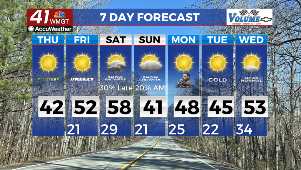
fall over the next several hours as an extremely dry and arctic airmass works its way into Middle Georgia. Morning low temperatures will range from the low 20s, teens in the mountains, to near freezing in far south-central Georgia. Gusty northwest winds will result in wind chills (feels like temperatures) in the teens across most places. In the far northeast Georgia mountains wind chills will range from -3 to -5 degrees! A Cold Weather Advisory is in effect for Fannin, Union, and Towns counties until 10 AM. These temperatures and wind chills will definitely make for a frigid morning commute so please bundle up! Increased fire danger is the other concern as we head into the afternoon as a result of gusty northwest winds. Northwest winds have increased this morning and will remain gusty for the better part of the day. Gusts as high as 20-30 mph can be expected this afternoon. Colder and drier air moving into the area will lead to Relative Humidity Values falling to the 25-35% range this afternoon. Relative humidity may brief dip below 25% in far south-central Georgia and eastern Georgia late this afternoon. A Fire Danger Statement has been issued for all of North and Central Georgia through this afternoon. For tonight, mostly clear skies will allow radiational cooling and temperatures to fall into the teens to low 20s by early Friday morning. Winds will not be as strong so wind chills are also expected to be in the teens to low 20s. High pressure begins to shift eastward during the day Friday however, dry weather will remain. Increasing south/southwest flow allows temperatures to rise to the upper 40s in the North to mid 50s further south. We are monitoring the potential for a weekend winter storm system. The models are showing a weak frontal system moving through the area Friday night into Saturday morning, however, it looks like temperatures will be warm enough to keep things mostly rain as it moves through. Some of the higher elevations of the North Georgia mountains could see some freezing or frozen precipitation but we are not expecting much in the way of accumulations from this first system. The second boundary moves into the region right on the heels of the first one with a developing wave attached to the tail end of the front. This second front dives south of the Great Lake states Saturday morning with wave moving southeast out of the Central Plains and into east Texas by Sunday morning. The front pushes into Northwest Georgia with the wave moving rapidly east along the front over the Louisiana/Mississippi Gulf coast. This front intensifies Saturday night/Sunday morning with the wave developing a closed low center along the Alabama/Florida Gulf coast. This low center moves east. With the cold temps in place across the area Saturday night most locations across north and central Georgia will see some freezing or frozen precipitation. This is just one model solution. Other models have multiple solutions for this weekend. Therefore, I am going with the majority of ensemble models bringing in some winter precipitation with about an inch or less accumulation across mainly Middle Georgia. It’s important for residents to pay attention to the forecast, as there is a potential for a storm system with significant impacts. Daytime highs are expected to get up into the lower 40s across Middle Georgia Sunday after this system moves through.