Chilly temps continue into New Years Day
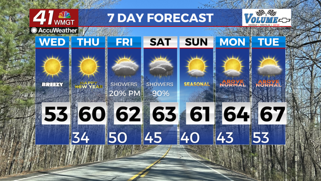
MACON, Georgia (41NBC/WMGT) – In a stark departure from the spring-like warmth we’ve been experiencing during much of the latter part of December, winter has made an abrupt 


return in the wake of Monday’s cold front. Subfreezing temperatures are punctuated by ongoing breezy northwest winds of 15-20 mph with gusts over 25-30 mph, have lead to wind chills in the teens to low 20s in most areas. Surface high pressure will drop southward into Texas while northwest flow remains in place aloft. With a fairly tight pressure gradient still situated across the area, northwest winds will remain elevated until this evening. These breezy conditions coupled with the very dry airmass continuing to filter into the state will lead to dangerous fire weather concerns this afternoon and early evening. As such, the National Weather Service has issued an areawide Red Flag Warning highlighting the dangerous fire weather conditions. Another cold night can be expected tonight with lows at least in the 30s areawide, although the slackening pressure gradient will lead to less frigid air temperatures. Persistent northwest flow continues while the center of the surface high will drop southward into the Gulf by Wednesday afternoon. Temperatures will begin a gradual rebound with highs in the low to mid 50s only slightly below to near normal. To kick off the extended forecast on Thursday, New Year’s Day looks to be a pleasant one, with continued moderation of our presiding dry airmass supporting sunny skies and highs in the mid-50s to lower 60s.