Scattered sprinkles start the new week
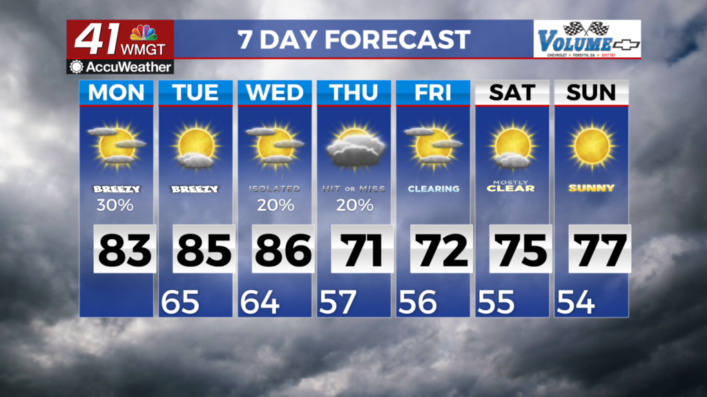
MACON, Georgia (41NBC/WMGT) – Low clouds with the potential for showers will start the new week. With easterly flow continuing and a Gulf low slowly meandering east, we do not expect 


 the pattern to change from today into Tuesday. With the increased cloud cover today, max temps will only top out in the upper 70s to low 80s, however, if cloud cover persists as much as it does today, these values will be lower. Starting the long term forecast on Tuesday, easterly low level flow begins to turn, reducing moisture transport into Middle Georgia. An upper level trough over the Great Lakes and Ohio Valley region sends a cold-front down into the southeast, assisting with this turning. Models have been inconsistent on the evolution of the front as it moves through Georgia, with run to run variation on the stalling potential in north Georgia as it out runs the upper level support in its dive south. While current models slow the front as it moves into the area Wednesday, they never fully stall and bring cooler air through the coverage area by Thursday afternoon. Previous runs temporarily stalled the front in north Georgia, slowing the progression of the cooler air. What this means temperature wise is a spread of 5-8 degrees between runs for the high temperature on Thursday. For precipitation, a more progressive front means precipitation chances spread further south through Thursday rather than being concentrated in the north. No matter the outcome, precipitation through Thursday is unlikely to be substantial to make a significant impact on current drought conditions. Temperatures generally decline through the forecast as the cold front moves through. Highs fall from above normal on Tuesday to near normal by Friday.


