Warmest day of the week, then storms arrive Thursday
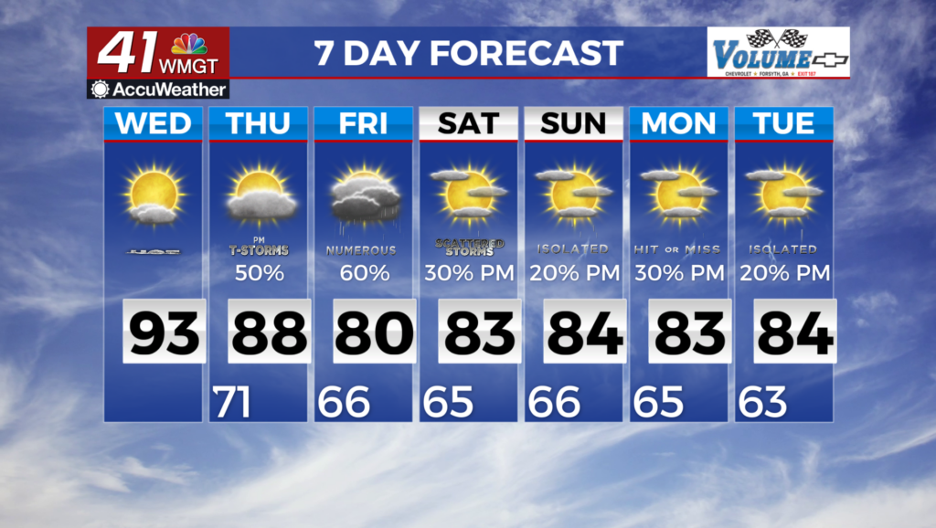
MACON, Georgia (41NBC/WMGT) – Temperatures will be well above average in most locations today. Today is expected to be the warmest day this week with a forecast high of 92 in the Atlanta 


 area. With
  temperatures looking to cool outside the forecast period this could very well be the last 90 of the year (fingers crossed). Moving into Wednesday evening, a cold front and upper level trough will begin to push through the area. This will likely bring a diffuse line of showers and thunderstorms ahead of the main front. Some of these storms may be severe. A cold front transverses Georgia on Thursday morning, bringing showers and thunderstorms to the state. Widespread activity is anticipated through Friday. Rainfall totals on the order of around an inch are likely for the majority of northern and central Georgia; locally higher amounts are possible, up to around 3 to 4 inches, with the greatest risk for heavier rains being over north Georgia. Although there is somewhat of a drying trend after Friday, models are suggesting that moisture levels will remain near or above seasonally typical values. In terms of the details of the forecast beyond Friday, there is only a medium level of confidence. Some models maintain higher levels of moisture over the southeastern United States. One factor in this difference is a weak disturbance with tropical moisture nearer to the coast this weekend, putting it north of the Bahamas and east of Charleston, SC on Sunday afternoon. It would appear that this disturbance is likely the remnants of a tropical wave that is just east of the Windward Islands. Additionally, there are some differences in the mid-to-upper level low that is forecast to be ejected off of a trough over the Great Lakes and Ohio River Valley at the end of the week. Jet streaks associated with this feature are likely to influence the convection potential. It is likely that the moisture levels will sufficient to combine with the instability that is available to result in some isolated to scattered thunderstorms during the afternoon and evening through the weekend. Moisture levels are likely to be somewhat higher over eastern Georgia, so the potential for convection will be greater there – but will likely only be around 20% chance by Sunday afternoon.