A wet start to the week as summer strikes back by midweek
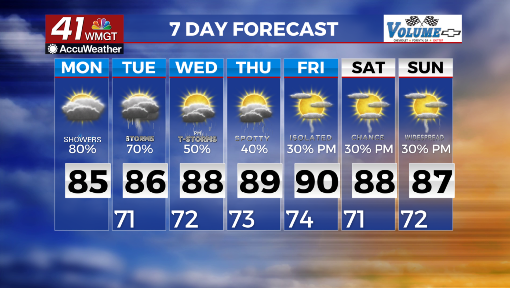
MACON, Georgia (41NBC/WMGT) – We will slowly start to see an increase in thunderstorm activity for Middle Georgia to start the new week. This afternoon thunderstorms will be mostly 

 limited to south of I-20 though lingering cloud cover over the metro Atlanta and Athens areas may put a lid on potential development north of a line from Columbus to Macon. Coverage will expand across the entire region. Severe weather is not expected due to cooler temps and an unimpressive set of dynamics, however, a few thunderstorms could have some strong gusty winds, especially if the cloud deck starts to break down in the afternoon. Temperatures will be in the low to mid 80s again today, but will slowly edge up tomorrow to the mid to upper 80s. This trend is set to continue through the long term. Hopefully everyone enjoyed the taste of fall, because that’s likely behind us as we move forward. While temperatures aren’t set to sky rocket overnight, we will see a steady increase through the week back to the upper 80s and lower 90s for most of the region. Upper level flow breaks down allowing for the return of gulf moisture which will increase temperatures, humidity and the chance for afternoon thunderstorms. None of the models indicate a break in this pattern as we look ahead. Temps will remain relatively steady and afternoons will see a slight chance for storms across the entire area.