Warm temperatures increase rain chances
MACON, Georgia (41NBC/WMGT) – Surface high pressure continues to dominate the weather pattern. Daytime temperatures will be noticeably warmer with forecast highs in the middle to 
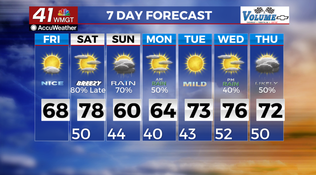
 upper 60s. The forecast concern will be fire weather. Continued dry conditions will keep low relative humidity values specifically for east Georgia during the afternoon. Rain begins moving into southwest Georgia early Saturday morning as the ridge of high pressure exits the area. There will already be a weak frontal boundary laying across south Alabama and south Georgia Saturday morning, however, we don’t expect much rain from it. A wave will poke out east of Texas Saturday morning and will ride along this frontal boundary. This will increase moisture into Georgia late Saturday into Sunday morning. Directly on its heels is a closed low center that also develops over eastern Texas Saturday, get caught up in the upper level flow and moves east into Georgia Sunday morning. This low pressure system will bring good precipitation chances to the area through Monday morning. By Monday morning the closed low system will be well east of the area off the Carolina coast. Some wraparound drizzle is possible. A very large and strong high pressure ridge begins developing along the Texas gulf coast and moves slowly northeast. This ridge will keep things dry through the middle of next week.