
Strong storms possible Friday along with cooler temperatures
Rain and storms stuck around for much of the day across Middle Georgia, but we are finally seeing a break from heavy rain. Showers and storms are possible overnight as temps stay mainly in the 70’s.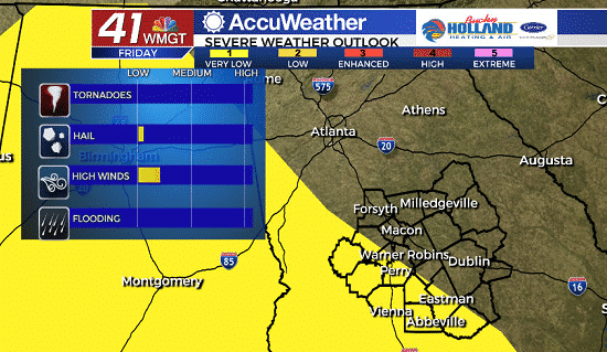
Tomorrow will bring another chance of afternoon showers and thunderstorms. This likely won’t be a total rain out, but a few storms could be strong to severe with the main threat being damaging winds.
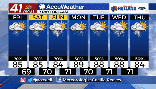
Temperatures through the weekend will be staying mainly in the mid 80’s with storm chances sticking around through Sunday.
Next week brings quite a few question marks as far as rain chances because it will be based on what happens in the Tropics/Gulf of Mexico…
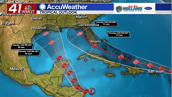
As of the 8pm update we have two tropical depressions that are both forecast to move into the Gulf of Mexico. TD 13 (the one that is in the Atlantic) is forecast to become a Hurricane by Monday and potentially interact with the peninsula of Florida.
If TD 13 moves into the Gulf (as forecast) Middle Georgia could see some serious impacts as far as rain, wind, and even tornadoes.
TD 14 is forecast to strengthen to a tropical storm and potentially make landfall along the Gulf Coast.
This forecast would bring two tropical storms into the Gulf at the same time, impacting much of the region.
That being said, we are still too far out to make any kind of definite forecast on impacts.
Be sure to stick with 41 NBC for the latest forecast as the forecast gets more refined.


Leave a Reply