Follow Meteorologist Dalton Mullinax on Facebook (Dalton Mullinax 41NBC) and Twitter (@MullinaxWX) for weather updates throughout the day. You can also watch his forecasts Monday through Friday on 41NBC News at Daybreak (5-7 a.m.) and 41Today (11 a.m.).
Rain returns this weekend
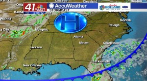
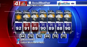
MACON, Georgia. (41NBC/WMGT) – Behind a cold front we have seen drier air, but that is just temporary as rain chances increase on Saturday afternoon with scattered showers and storms.
TODAY.
High pressure is going to dominate our area once again this afternoon, which means a sunny sky with temperatures in the low 90’s is in store. Lower humidity also hangs around today as well! Overnight tonight we will begin the evening with clear skies and temperatures falling quickly after sunset. Early Saturday morning clouds will begin to roll into our area as temperatures fall into the low and middle 60’s.
TROPICS.
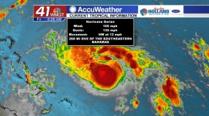
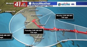
As of 5 am, Hurricane Dorian continues to maintain strength as a Category 2 hurricane in the Atlantic. The latest National Hurricane Center forecast track maintains a major hurricane landfall on Florida’s east coast late on Monday and early into Tuesday. Impacts for Middle Georgia are still to be determined depending on the track Dorian takes.
WEEKEND.
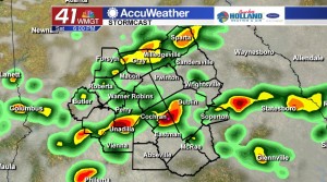
Scattered showers and storms are in the forecast for Saturday with less rain expected on Sunday. Temperatures will be topping out in the upper 80’s and lower 90’s during the afternoon hours.
NEXT WEEK.
Our forecast is going to depend on the track that Hurricane Dorian takes. If Dorian hugs the southeast coast then rain totals will be much less across our area. If the storm tracks further west before making a turn north, our rain totals will increase. A lot will be ironed out in the coming days.


Leave a Reply