Drier air returns later this week
MACON, Georgia. (41NBC/WMGT) – After temperatures topped out in the low 80’s yesterday, temperatures will be on the rise today and will continue to return to our normal range for this time of year as we head throughout the work week.
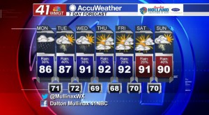
TODAY.
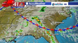
Partly cloudy conditions will greet the Middle Georgia skies this afternoon as a stationary front to our south and west begins to lift back north. A few isolated showers are possible this afternoon as temperatures will top out in the middle to upper 80’s. Showers and a few storms will continue into the late evening and early overnight hours as well. Temperatures tonight will bottom out in the upper 60’s and lower 70’s under a partly cloudy sky.
TOMORROW.
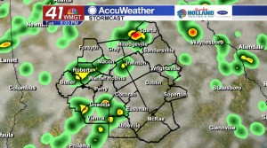
Our gradual warming trend is going to continue into your Tuesday. Afternoon high temperatures will top out in the upper 80’s with scattered showers and storms moving through the area ahead of a cold front. In the overnight hours temperatures will fall back into the lower 70’s.
REST OF WEEK.
Behind the cold front passage on Wednesday, drier air will temporarily work its way into our area and will take us into the rest of the work week. Temperatures will rebounding to the lower 90’s.
TROPICAL STORM DORIAN.
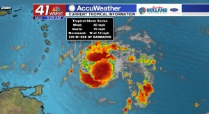

As of 5 am this morning, Tropical Storm Dorian continues to strengthen. The National Hurricane Center has this storm system strengthening into a Category 1 Hurricane later this week.
 Follow Meteorologist Dalton Mullinax on Facebook (Dalton Mullinax 41NBC) and Twitter (@MullinaxWX) for weather updates throughout the day. You can also watch his forecasts Monday through Friday on 41NBC News at Daybreak (5-7 a.m.) and 41Today (11 a.m.).


Leave a Reply