
Heat and humidity will be the story over next few days
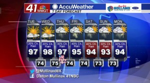
MACON, Georgia. (41NBC/WMGT) – Hot and humid weather is going to hang around through mid week before we see temperatures relax back into the lower 90’s.
TONIGHT.
Isolated showers and storms that bubble up this evening will fizzle out by sunset and we will be left behind with a mostly clear sky as a ridge of high pressure keeps us dry for the most part. Overnight temperatures will be running just a few degrees above average for this time of year in the low and middle 70’s.
TOMORROW.

Even warmer weather is on the way for your Tuesday afternoon as temperatures will be in the upper 90’s and approaching the 100° mark. When you factor in the humidity many areas will feel like the triple digits during the peak heating of the afternoon hours.
Heat Safety Tips:
- Avoid as much outdoor exposure during the hottest hours of the day which is usually noon through 6 pm.
- Stay hydrated. Drink plenty of water before, during, and after and outdoor work.
- Wear sunscreen.
- Take care of each other. Infants and the elderly are the most susceptible to heat related issues.
EXTENDED FORECAST.
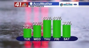
Wednesday will be much like Thursday with just a few isolated showers and storms in the forecast. For the Fourth of July I am expecting temperatures to be in the middle to upper 90’s with increasing rain chances. Showers and storms look to be more numerous as we head into Thursday afternoon. Much like any summer afternoon, shower and thunderstorm development will calm down after sunset, so at this time fireworks shows still look to be good!
 Follow Meteorologist Dalton Mullinax on Facebook (Dalton Mullinax 41NBC) and Twitter (@MullinaxWX) for weather updates throughout the day. You can also watch his forecasts Monday through Friday on 41NBC News at Daybreak (5-7 a.m.) and 41Today (11 a.m.).


Leave a Reply