
Thunderstorm coverage increasing into weekend
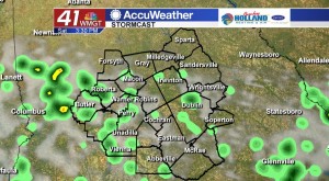
MACON, Georgia. (41NBC/WMGT) – Shower and thunderstorm coverage will be isolated today, but better coverage moves in as we head into the weekend.
TODAY.
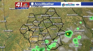
Isolated showers and thunderstorms will be back this afternoon as Atlantic moisture is ushered back into our region by a southeasterly breeze. Temperatures this afternoon will top out in the low 90’s, but when factoring in humidity it will feel like the middle 90’s. A partly sunny sky this afternoon will give way to a partly cloudy sky overnight. Temperatures overnight will be running right at the average high for this time of year (70°).
WEEKEND.
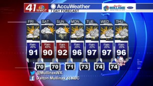
Showers and storms will become more numerous as we get into the weekend. On both Saturday and Sunday typical summertime showers and storms will bubble up across our region. Temperatures on both days will top out in the low 90’s under a partly sunny sky.
NEXT WEEK.
We crank up the heat next week as most areas will stay dry. An isolated shower or storm cannot be ruled out during the afternoon hours, but rain chances are running at 20% next week. Temperatures during the afternoon hours will top out in the middle to upper 90’s, but when you factor in humidity heat indices will be in the triple digits.
 Follow Meteorologist Dalton Mullinax on Facebook (Dalton Mullinax 41NBC) and Twitter (@MullinaxWX) for weather updates throughout the day. You can also watch his forecasts Monday through Friday on 41NBC News at Daybreak (5-7 a.m.) and 41Today (11 a.m.).


Leave a Reply