
Cold front brings showers tomorrow
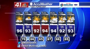
MACON, Georgia. (41NBC/WMGT) – For the sixth consecutive day a record high temperature was tied or broken at the Middle Georgia Regional Airport. Temperatures are going to fall into the low 90’s by the weekend.
TODAY.
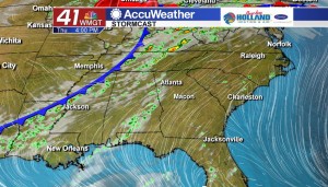
High pressure continues to break down as a cold front from the west will move through the region tomorrow. Today though we will see a mostly sunny sky with temperatures in the middle 90’s. Winds will be coming out of the southwest from five to ten miles per hour. We will begin to see clouds rolling in later this evening and that will allow for a partly cloudy sky this evening. Temperatures overnight tonight will be falling into the upper 60’s and lower 70’s.
TOMORROW.
A cold front is finally going to move through our area bringing with it a chance for isolated showers and thunderstorms. Temperatures tomorrow will also be on the cooler side compared to the past several days due to the added cloud cover. Afternoon high temperatures will top out in the low to middle 90’s before falling into the middle 60’s overnight.
WEEKEND AND BEYOND.
A dry weekend is in store across Middle Georgia. Temperatures on both Saturday and Sunday will be in the low to middle 90’s under a mostly sunny sky. By the time we get into the next work week we will see a chance for rain returning on Tuesday and Wednesday.
 Follow Meteorologist Dalton Mullinax on Facebook (Dalton Mullinax 41NBC) and Twitter (@MullinaxWX) for weather updates throughout the day. You can also watch his forecasts Monday through Friday on 41NBC News at Daybreak (5-7 a.m.) and 41Today (11 a.m.).

Leave a Reply