Triple digit heat moves into Middle Georgia this week
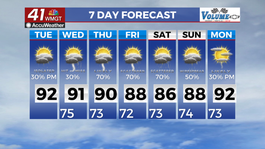
Intense heat will be moving into Middle Georgia this week with highs warming to the 100s. Hazy skies stick around Tuesday

A dome of high pressure that has been over the southwest is going to be pushing into Middle Georgia through the end of the week.
This will allow our high temperatures to warm into the triple digits starting on Tuesday, continuing through the week.
The addition of lower humidity will at least make the heat a bit more comfortable (it’s all relative I guess).

Not only will it be hot on Tuesday, but the hazy conditions brought on by the Canadian wildfire smoke will be sticking around.
I don’t expect the smoke to be quite as thick as it was today, but we should still see a haze.
This haze will slowly filter out by Wednesday evening.

By the middle of the week, we will see a return of moisture (i.e. humidity).
Not only that, but we will also see the chance of storms back in the forecast.
A complex of storms will be pushing in from the north, bringing the potential for gusty winds and heavy rain.

The combo of heat and humidity will result in heat index values up to 110°.
It is very possible that we see a Heat Advisory by the end of the week.

Rain chances will be on the increase through the second half of the week.
Several lines of showers and storms will be moving in on Friday, which will start our cool down for the weekend.

Highs over the weekend will be staying mainly in the low 90s, with numerous showers and storms possible.