
Temperatures soar into the 70’s in Middle Georgia ahead of another cold front
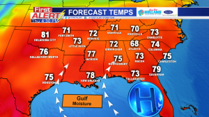
MACON, Georgia (41NBC/WMGT) – Temperatures across the southeast today are likely to rise into the 70’s before a cold front creates a brief cool down this weekend.
A high pressure system is hanging out along the west coast of Florida and in the Gulf of Mexico. Winds rotate clock-wise within a high pressure system. All the warm, moist air from the Gulf of Mexico is being transported over the southeast. This wind flow is also the reason it has been extremely cloudy as of late.
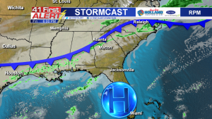
As this high pressure system develops in the Gulf, a cold front will move into the mid-west. By the time the front enters the southeast, the line of precipitation will diminish. Isolated showers are possible across Middle Georgia again Friday. The chance for rain also extends into the weekend as the front stalls out in south Georgia Saturday.
Behind the front, comes a brief “cool spell”. Temperatures will drop from the mid-70’s Saturday into the upper 60’s Sunday as winds shift to the northwest and cooler air flows south. With the tropical air returning early next week, temperatures will most likely climb back into the 70’s. Clouds will stick around for the majority of the next seven days.

Connect with Meteorologist Kristen Kennedy on Facebook and Twitter for weather updates throughout the day. You can also watch her forecasts Monday through Friday on 41NBC News at Daybreak (5-7 a.m.) and 41Today (11 a.m.).


Leave a Reply